Here is a quick look at what the Great Bend City Council did Monday night:
• Held a 90-minute executive session to review city administrator applications and narrow the field to the finalists. Afterwards, no action was taken.
• Approved a rezoning request from Christopher Tyree for 1011 Taft, from commercial to two-family. In order for Tyree to sell the house and the purchaser to secure a loan to purchase the real estate, the bank is requiring that the real estate be zoned appropriately for the current use. The Planning Commission conducted a hearing in the matter and has recommended that the requested rezoning be approved, City Attorney Robert Suelter said.
• Approved the purchase of property from Nels Lindberg to provide access to land isolated by the condemnation of the bridge on Park Street at a cost of $25,000 plus miscellaneous costs and the costs of moving a fence on the real estate.
• Approved abatements at: 1622 19th, motor vehicle nuisance, owned by Karen Hayward and Sandra Wright; 800 Monroe, accumulation of refuse, owned by Israel and Noemi Sanchez; 814 Monroe, motor vehicle nuisance, owned by Fred McNett; and 705 Heizer, accumulation of refuse, owned by Jaime and Maria Santana.
• Heard a report from Community Coordinator Christina Hayes. She highlighted the upcoming June Jaunt which starts June 1 and the Mega Motor Weekend (Airfest, drag races and motocross shootout) that occur in September.
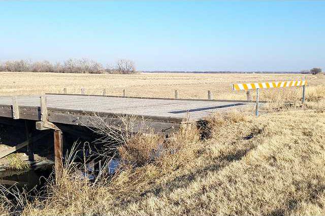
Noting it was cheaper than replacing the condemned bridge over the Lischevsky Ditch east of Great Bend, the Great Bend City Council Monday night purchased property that would allow access to farm land that would otherwise have been isolated.
Following negotiations, the land is being bought from Nels Lindberg at a cost of $25,000, plus the cost to move a fence and miscellaneous expenses, like the replacement of a cattle guard. A new bridge would have cost about $150,000, City Attorney Bob Suelter said.
On Jan. 15, the council learned Lindberg had met with city’s on-call engineering firm Professional Engineering Consultants of Wichita. They reached an agreement whereby the city could purchase an easement at the northern end of the property, which amounts to just shy of one acre.
This would allow entry to the ground and eliminate the need to replace the span, which crosses the ditch about a quarter mile east of town on the south side of the parcel. Lindsberg retains access to other land he owns in the area.
Replacing the bridge was first on the council’s Jan. 2 agenda, but council members questioned the cost and legalities of the issue and tabled it.
It was on the 15th the council authorized Interim City Administrator George Kolb, Suelter and Mayor Joe Andrasek to negotiate a price for the 50-foot easement. The city had $40,000 budgeted for the project and would have had to come up with more funds to replace the bridge, but that is not an issue now.
Background
On Jan. 2, Kolb reported that Wichita Concrete Pipe of Wichita had submitted a bid to repair the condemned bridge at a cost not to exceed $149,500. The bridge provided access across the ditch to land owned by the Dorothy Morrison Charitable Trust, and the city was contractually obligated to replace the rickety span. The old bridge, which was deemed unsafe last summer, was placed over the channel to provide the only access to the farm land when the drainage ditch was established in the late 1930s. The farmer who works the ground now wanted to farm it this spring had been granted access via another property owner’s land, but that is no longer an option and the Morrison Trust asked that access be reestablished.
However, it was suggested by council members that other local contractor options be explored, such as L&M Contractors.
History
The Lischevsky Drainage Ditch was designed and built in the late 1930s as a part of a Public Works Administration project. This project was financed partially by the city and partially by the United States government.
It provides drainage to the northeast portion of Great Bend via a drainage ditch from north of 24th and Frey down the west side of Frey Street to just south of 21st Street where it crossed Frey Street to the east side.
The ditch then ran south to 16th Street where it was taken southeasterly to the north side of Park Street extended. At Park Street extended, the ditch continued east eventually curving south to the Wet Walnut Creek and the Arkansas River. This project also raised Frey Street to allow the ditch to accommodate more water.
Before it was built, the Dorothy Morrison Trust property had access to Frey Street by a farm drive only on the north side of Park Street extended. The real estate needed for this project was a 30-foot wide tract taken by eminent domain.
As a result, the Morrison Trust land was cut off from any public road access. To mitigate the damage, the plans called for a bridge which was specifically constructed to provide this access.
Since the bridge’s deterioration, access has been arranged by the city.


