“Not all drones are created equal,” Dr. Kevin Price, a Kansas State University professor of agronomy and geography told the audience at the Wednesday noon presentation on drone technology at the Great Bend Farm and Ranch Expo.
The unmanned aviation vehicles (UAVs) Price spoke of at the Barton County Young Professionals sponsored demonstration have a completely different mission than Predator class drones used by the military for reconnaissance purposes. Instead of gathering information about enemy locations, these small unmanned drones are being put to work gathering the same information in minutes that have taken hundreds of man hours of hands on work for ag researchers, farmers and agronomists to perform, and its being done comparably cheaply to boot.
KSU has been using the technology to pinpoint desirable breeds in test plots in minutes, a task that previously totalled 15,000 field hours. Instead of having to harvest and test individual grains from several samples to determine which breeds had the genetic factors, a simple picture can tell the whole story. An infrared camera can be attached to a drone, taking pictures with a one by one pixel resolution, sending the information to an onboard computer equipped with a spectroradiometer that registers two wavelengths of colored light with one pass of the plane. Since the human eye can’t see infrared light, the computer converts the image to near infrared pictures. Healthier plants show up darker in the images because there is more chlorophyll present.
“The redder the picture, the greener the plant,” Price said. Less chlorophyll is present when a plant is stressed, so disease or drought stress can be identified before it can even be seen by the human eye, he said. Scientists in turn can rapidly tell which parts of the field to harvest, and which to destroy.
By taking a photo of an area and identifying certain plants, the infrared cameras can then use that information for determining different types of grasses in a pasture.
Price showed a near infrared photo of one invasive grass that is taking over the traditional prairie grasses in Kansas, Old World Bluestem.
“It’s estimated that we could lose 50 percent of the weight gain on cattle due to this grass becoming a monoculture,” Price said. Drones can be used to assess range conditions, and also can make it apparent where overgrazing may be taking place. Not only can it identify the grass, it can also determine what the weight or other factors sought are in the stand.
Other applications
With the invasion of red cedar forests in Kansas, researchers are finding ways to turn it into a renewable energy resource, chipping the wood for boilers or turning the tree mass into biodiesel. Price said one company is considering placing a refinery in Kansas, and the drones are being used to help determine the best location, which would be close to enough red cedar to ensure a ready and inexpensive supply.
Ranchers have suggested using the technology for counting cattle, and before long it may even be possible to identify ear tags, though that capability is not yet available. They’ve also asked about checking the health of ponds with the drones.
The Kansas Department of Wildlife and Parks asked Price to help them check for blue-green algae blooms in lakes, and were impressed with the photos received. Manually testing lakes for outbreaks are costly and time consuming using traditional methods, and flyovers in manned airplanes are prohibitively expensive.
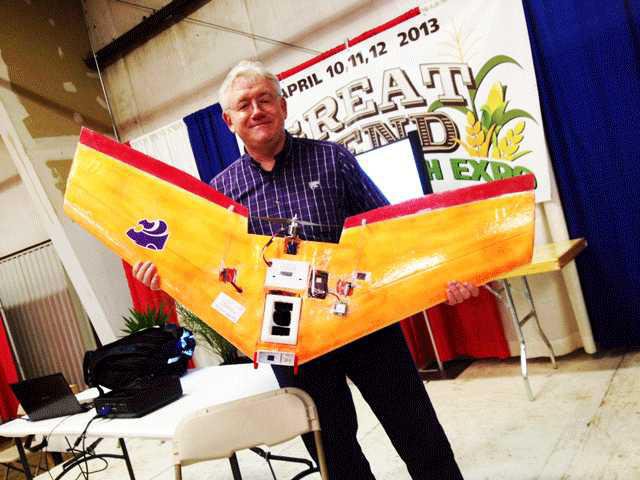
Small and lightweight, in a class by itself
Two models, the Hex-copter and the Zephyr wing, were on display. About the size of a good-sized kite or a large remote control helicopter one might by at a mall kiosk during the holidays, these drones may change the way farmers and ranchers do their work in the very near future, according to Brett Chilcott with Ag Eagle, LLC., another demonstrator. Able to photograph 600 acres in as little as 20 minutes from around 400 feet off the ground, weighing about the same as a Canadian goose, the technology is already beginning to help farmers increase yields by pinpointing areas of concern, such as drought stress and disease, things that are tricky to pinpoint from the ground.
In 1989 when Price first came to Kansas from Utah, there was little enthusiasm for agronomy applications with satellite technology. That’s because one pixel of information represented several acres at the time. In the early 200’s, when Price and students were experimenting with building the first drone prototypes, the accelerometers and gyros that were required ensure the data received was usable was quoted at $250 thousand, he said. That was too much.
But today, thanks to widespread use of the technology in cell phones and tablet computers, the price has finally come down, and according to Chilcott, a farmer will within months be able to purchase a wing drone, the computer and software for around $6 thousand.
Ag Eagle LLC, is working closely with the Federal Aviation Administration to come up with guidelines that will allow the technology to be used for commercial applications. It’s something the FAA has been examining closely for years, and is getting closer to approving. Privacy advocates are nervous about the use by public law enforcement, but hobbyists and private citizens as well as commercial companies are driving the regulatory agency to open the door, according to an April 1 USA Today story, “Drone use surges as FAA seeks to regulate unmanned aircraft.” Chilcott said the United States is already ten years behind Europe and Japan in the use of the technology. The FAA’s okay will be necessary before services can be offered by commercially.
Web resources:
USA Today http://usatoday30.usatoday.com/news/nation/story/2012-04-01/drones-faa-regulation/53932640/1
CNN http://money.cnn.com/2013/04/10/technology/innovation/cheap-drones/
Drones give birds eye view, make fast work for ag apps