
WICHITA — The National Weather Service in Wichita issued a severe thunderstorm warning for Ellsworth County in central Kansas until 6:15 p.m. Locations impacted include Ellsworth, Wilson, Kanopolis, Holyrood, Lorraine, Kanopolis Lake, Ellsworth Airport and Kanopolis State Park. This includes interstate 70 between mile markers 206 and 228.
At 5:10 p.m. a severe thunderstorm was located over Lorraine or 9 miles east of Claflin moving northeast at 15 mph. Hazard is 60 mph wind gusts and quarter-size hail.
Impact is hail damage to vehicles is expected. Expect wind damage to roofs siding and trees.
• At 4:37 p.m., the National Weather Service in Wichita has issued a severe thunderstorm warning for northern Russell County in central kansas until 545 p.m. A severe thunderstorm was located 8 miles west of Luray or 14 miles north of Russell moving northeast at 20 mph. Locations impacted include Luray, Paradise and Waldo.
Hazard is 60 mph wind gusts and penny size hail. Iimpact — expect damage to roofs siding and trees.
• The NWS issued a significant weather advisory for northern Rice County in central Kansas until 5:15 p.m. At 4:22 p.m. National Weather Service meteorologists were tracking a strong thunderstorm over Lyons moving northeast at 25 mph. Hail up to the size of dimes and wind gusts up to 50 mph will be possible with this storm.
Locations impacted include Lyons, Little River, Geneseo and Frederick.
Precautionary/preparedness actions — be prepared to take shelter in the event the storms intensify and become severe or a warning is issued by the National Weather Service.
An isolated strong to severe thunderstorm may develop late Wednesday afternoon or early Wednesday evening. if a thunderstorm can develop, nickel sized hail and damaging downburst wind gusts to 70 mph are possible. the slow movement of the storms may also lead to localized heavy rain.
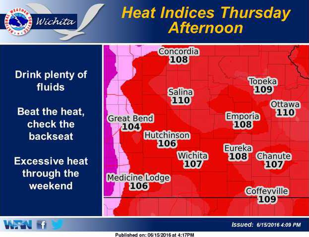
Dangerous heat indices of 102 to 107 degrees will prevail across much of the area Wednesday evening with the highest indices along and east of a Salina to Hutchinson to Wichita line.
Ellsworth County under warning

