
Local officials will soon have a new, sharper birds-eye view of Barton County.
The County Commission Monday morning approved the purchase of high-resolution digital aerial photography through the Surdex Corporation of Chesterfield, Mo. The county had the opportunity to do this as part of the State of Kansas contract with the company for updated Next Generation 911 (NG911) imagery, said county Cartographer Bj Wooding.
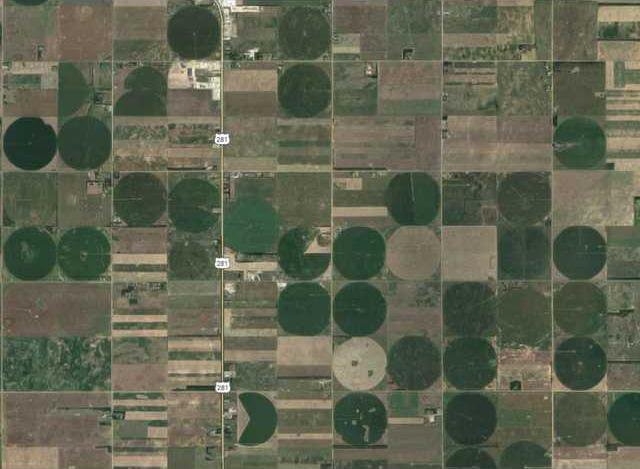
The state is acquiring one-foot-pixel-resolution digital orthoimagery from Surdex. This works well for the rural areas, but a higher resolution of three-inch pixels is preferred for urban areas, Wooding said, adding this is also available, for an extra charge.
She suggested that one-foot imagery be purchased for the county and three-inch imagery for the areas in around and around the cities of Claflin, Ellinwood, Great Bend and Hoisington with the cities contributing to the project. The cities are all onboard with the idea.
At a total cost of $28,500, the cities will reimburse the county $14,249.62.
The images are widely used, Wooding said. They are accessed by 911, first responders, Road and Bridge personnel, county appraisers and engineers, as well as abstractors, and oil and gas producers.
Aerial photos were originally mandated by the state in 1989 for reappraisal purposes.
The county most recently paid for imagery in 2010, and this was one-foot for rural areas and six-inch for the cities, Wooding said. At that time, the package cost between $50-60,000.
What does this resolution mean?
In digital photography, a pixel (picture element) is the smallest element of an image. The average digital camera has a resolution of 2,240 x 1,680 pixels per inch, or four megapixels.
But, what the county is buying is much more detailed. In a one-foot image, each pixel equals one foot and in a three-inch, each pixel covers three inches.
With one-foot, officials can tell if a vehicle is a car or SUV, and with three-inch, can they spot fire hydrants, manhole covers and utility boxes. But, should someone be looking at the time of the photo pass, their face will not be recognizable – that would take even higher resolution.
According to the U.S. Geological Survey, high-resolution orthorectified images combine the image characteristics of an aerial photograph with the geometric qualities of a map. An orthoimage is a uniform-scale image where corrections have been made for feature displacement such as building tilt and for scale variations caused by terrain, sensor geometry and camera tilt.