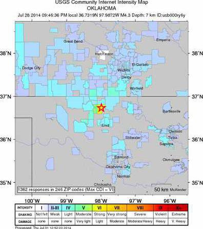
According to the United States Geological Survey, the 4.3 magnitude earthquake that occurred near Medford, Okla. on Monday, July 29, was felt well into Kansas, and that includes a handful of local persons who contacted the USGS through their internet website to report their experiences. By answering questions on the Calculating Community Internet Intensity survey, respondents help determine the varying intensities felt by zip code. This helps researchers document the size and scope of the event almost instantly. The information is compatible with the ShakeMap which records actual ground motion picked up by seismometers after an event.
Great Bend and Hoisington each have one respondent listed, The Intensity in this area so far is rated as a two on the Modified Mercalli Intensity Scale, which depicts shaking severity associated with earthquakes. Activity under level five is not mapped. A two means people sitting or on upper floors of buildings felt the activity. The highest MMI rating, a six, came from Nash, Okla. with four people responding, followed by a rating of five from Jet, Okla., with two respondents and lower ratings as the distance from the epicenter increased. The highest number of reports came from the Wichita, area, with the highest MMI rating a three.
In the past 24 hours, the USGS has recorded five additional earthquakes in the same area of decreasing MMI ratings, with the latest one happening at 6:09 a.m. Thursday morning, with an MMI rating of one, meaning it was not felt.
The USGS encourages people to log in and complete the questionnaire even if they did not feel any tremors after an event. In areas of lighter shaking, the “not-felt” responses are needed to prevent the average zip code intensities from being too high. Without them, the lowest intensity places may be biased slightly upward. The survey can be accessed at http://earthquake.usgs.gov/earthquakes/dyfi/ .
Earthquake felt locally