FORT LARNED — Archeologist Steven De Vore has a good idea where the dead bodies are buried near the Fort Larned National Historic Site.
But it would require some excavation work to determine the precise location where burial grounds are located northeast of the current Fort Larned historical site.
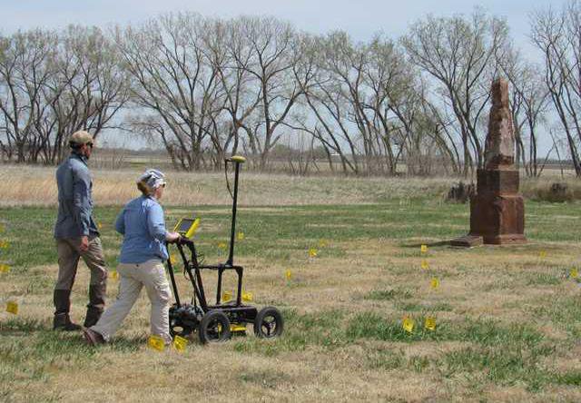
Project manager De Vore from the National Park Service’s Midwest Archeology Center (MWAC) coordinated a crew from April 4-15 that surveyed 16 acres at Fort Larned using non-invasive geophysical surveying methods like magnetic, resistance, conductivity and ground penetrating radar.
De Vore was assisted by archeological technicians Allan Wolfrum and Clare Connelly, Fort Larned volunteers, and two inmates from the Kansas Department of Corrections.
“We did a radar magnetic survey in the cemetery and we believe we picked up some of the graves,” De Vore said. “We saw areas that line up in rows. The best we can tell they are probably graves. I can see some evidence of graves, but it’s hazy in some spots. We can get an idea of the outline of the graveyard.”
Historical accounts indicate that deceased civilians and military personnel, perhaps as many as 100, were buried near Fort Larned.
“What I’m probably picking up are graveshafts two feet from the surface,” De Vore said. “Most times, the ground settles.”
Although the existing sandstone buildings at the fort represent a nearly complete frontier military post, they are actually just part of several buildings that once comprised Fort Larned.
Other support structures, like the laundry quarters and the adobe post hospital surrounded the current sandstone buildings. Most buildings were constructed of wood or adobe and were torn down or allowed to decay.
“We rely on historical information,” De Vore said.
DeVore’s crew provides plausible evidence where existing buildings might have been, Their investigations provide clues about any existing buried archeological features in the ground-like building locations and stone outhouse foundations. The survey helps determine whether any of these features are important to the overall integrity of the fort complex and its history.
“We got a good indication of where the stables were located,” De Vore said. “There were 100 stalls and a cavalry unit that escorted the mail delivery.”
DeVore said the instruments indicate disturbances as much as six feet below the surface.
“It’s always interesting to hear the historical stories and the military history,” De Vore said.
De Vore will prepare a Fort Larned report on the analysis of the data and interpretation of that data that help in future planning efforts.
“There may be more work required to verify an assumption,” he said. “There may be some excavation and testing performed to see any features that are related to the stables.”
The site was roped and staked into 20-by-20 meter grids to accurately document where different finds were located. The team used surveying equipment to make their grids to ensure precision and accuracy in their placement and measurements.
“Once everything is on the grid, you know exactly where everything is located,” De Vore said. “I make a sketch map where anything is located above the ground, which can affect magnetic surveys. We take a GPS unit and map in everything.”
• Magnometers measure the overall magnetic qualities of the earth and can detect variations within the magnetic field, which could indicate below ground features or buried objects.
• Ground penetrating radar use pulses of radar transmitted into the ground, which are then reflected back to the machine. The signal strength and amount of reflection time gives the archeologist an idea of whether or not underground features or objects are present.
• An electric resistivity survey, conducted with an alternating electromagnetic current through two probes, measures the ability of soil to resist electric current. Buried features or objects tend to have a measurably different resistance value, which can be used to map their location.
Digging a mystery
Researchers investigate Fort Larned site