Editor’s Note: Local historian David Clapsaddle writes about aspects on the Santa Fe Trail. This Rails to Trails series profiles how Santa Fe Trail freight, passengers and mail shifted from the overland trail to railways.
By DAVID K. CLAPSADDLE
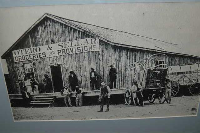
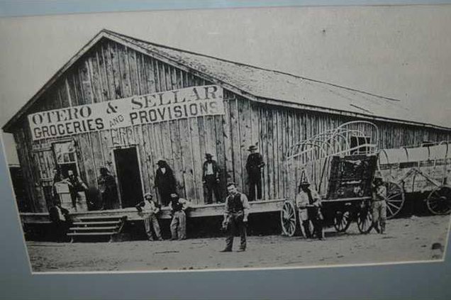
Erecting huge warehouses, the firms served as wholesale outlets supplying Santa Fe traders, both Mexican and American.
While Fort Harker remained the official railhead, the Barlow, Sanderson Company moved its headquarters to Ellsworth. To accommodate the ever-increasing traffic, an auxiliary road was developed running south from Ellsworth a few miles to connect with the regular Fort Riley-Fort Larned route emanating from Fort Harker.
During 1866-1867, the Fort Riley-Fort Larned Road remained free from Indian attack due in large part to the presence of the 37th Infantry stationed at Fort Harker and the various stage stations between the Smoky Hill and Walnut Creek.
However, with the transfer of Baldwin’s company to Fort Wingate, N.M., Sept. 3, 1867, trouble returned to the road.
Later in the month, Cheyennes killed and scalped a man near Plum Creek before pressing on to Cow Creek. There, one of the Cheyennes fired his pistol through the picket wall of the station house killing one of the occupants. The approach of a southbound stage frightened the Indians away, saving the other stage company employees from sure death.
The incident, which signaled an end to Indian depredations on the Fort Riley-Fort Larned Road, may well have predicted the end of the road itself.
In the following month Union Pacific trains were running on a regular schedule to Hays City.
The forwarding companies at Ellsworth disassembled their buildings, loaded them on flat cars, and transported them to Hays City. There, they were quickly reassembled, and soon the forwarding companies were once again in business.
Such was to be repeated at every new railhead as the railroad moved west through Kansas and into Colorado Territory.
Fort Dodge, established in 1865, was initially supplied by goods freighted from Fort Leavenworth down the Santa Fe Trail. However, with the arrival of the UP at Junction City in June 1866 and at Fort Harker on year later, supplies were shipped to these respective railheads and transported by wagon to the Fort Zarah juncture of the Santa Fe Trail and on to Fort Dodge.
By October 1867, the tracks of the Union Pacific pushed westward to newly founded Hays City. Thus, this little municipality became the eastern terminus of the Santa Fe Trail, and nearby Fort Hays superseded Fort Harker as the supply depot for the distribution of military goods to the Southwest.
In the spring of 1867, Gen. Winfield Scott Hancock, commander of the Department of the Missouri, transversed Kansas with 1,500 troops, making a show of force to the southern plains tribes.
During this campaign, Hancock, old quartermaster that he was, recognized the need for a road between Forts Hays and Dodge. Subsequently, Hancock, writing to Gen. Philip Sheridan, his replacement as commander of the Department of the Missouri, stated:
“My impression is that the real route of travel for emigrants hereafter will be from Fort Hays or Harker (most probably from Hays) directly across to some point a little west of Dodge, crossing Walnut Creek and branches of Pawnee Fork, where the country affords excellent grass, good running water, plenty of wood, good roads—woos, water, and grass at convenient intervals.”
Soon after, December 1867, Lt. Col. John W. Davidson, inspector general for the Department of the Missouri, wrote Sheridan proposing an itinerary for a 75-mile route between the two posts.
Fort Hays to Smoky 10 miles — Good water, grass, some wood and good crossing.
Smoky to Big Timbers, 8 miles — Wood, grass and water pools, never failing.
Big Timbers to Walnut Creek, 7 miles — Good water, grass and wood in abundance, bad crossing, requires a one span bridge.
Walnut Creek to N. Pawnee, 12 miles — Wood, water, grass abundant. Very bad crossing requires bridge, probably two spans.
N. Branch to Middle, 13 miles — Wood, water and grass abundant, bridge required.
Middle to S. Branch, 13 miles — Abundant water, grass and wood, fair crossing.
S. Branch to Ft. Dodge, 12 miles.
(To Be Continued)
Santa Fe rails move from Ellsworth to Hays
Trails to Rails Part 4