By David K. Clapsaddle
Santa Fe Trail Ambassador David Clapsaddle is a frequent contributor to Wagon Trails. This is another in his occasional series on stream crossings on the Santa Fe Trail.
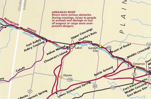
The Arkansas River has its source in the Rocky Mountains of central Colorado near Leadville, Colo. and flows southeast to Pueblo before taking an easterly orientation to the Kansas line and continuing on to a point near Ford, Kansas.
Many Kansans mispronounce the word “Ar-Kansas.”
Corresponding to the advent of the Cimarron Crossing, Francois X. Aubry conducted an unsuccessful attempt in the spring of 1851 to pioneer a new road from near Cold Spring in the present Oklahoma panhandle to the Arkansas River.
In the following fall, his second attempt resulted in “an excellent wagon road, well supplied with water and grass, and avoiding the Jornada and the Cimarron Trail altogether.”
The route was well documented by William Allen in 1852.
He wrote that his party struck “the river 12 miles above Chouteau’s Island and 58 miles above the point where the Cimarron Road crosses the Arkansas.”
In 1866, the crossing was reported to be 11 miles above Chouteau’s Island, 71 miles above the Cimarron crossing, and five miles above Fort Aubrey, the short-lived army post named in honor of Francois Aubry.
The so-called middle crossing fell into disfavor in 1861 with the advent of mail service to Fort Wise in present Colorado and the use of the Bent’s Fort Road by some government freight contractors during the Civil War.
Eschewing the regular route to lower Cimarron spring, the mail coaches and some freight wagons pursued the north bank of the Arkansas to Bent’s Old Fort where they forded the river to follow Timpas Creek to the southwest.
By 1868, the Union Pacific (changed to Kansas Pacific in 1869) arrived at the little railroad town of Phil Sheridan in present Logan County, Kansas.
From that point, mail, passengers, and freight were dispatched down a newly developed road through Fort Wallace and on to Fort Lyon near present Las Animas, Colorado.
Consequently, overland traffic on the Bent’s Fort road east of Fort Lyon essentially ceased while traffic to the west continued to use the ford at Bent’s Old Fort. In 1870, the railroad reached Kit Carson, Colorado, from which two roads departed. The first, a stage route, took a southerly orientation to Fort Lyon.
The second, a freight road developed by George McBride and Dick Wootton ran due south from Kit Carson before turning southwest to Bent’s Old Fort and seven miles farther west to the site of King’s Ferry where La Junta, Colorado, was later established.
There Messrs. McBride and Wootton constructed a toll bridge under the auspices of the Kit Carson and Fort Union Bridge Company. Regardless of the imposing title of the company, according to P. G. Scott, an 1870 traveler, the bridge was “a very common wooden affair...
The lower crossing was originally situated five miles west of the Caches.
Such is at odds with many writers of the 20th century who have placed the lower crossing at the confluence of Mulberry Creek with the Arkansas River at the western end of the South Bend.
These writers are well represented by Hobart Stocking who wrote, “Before many wheels marked the Road, traders with merchandise on packhorses sometimes left the Arkansas and the Lower crossing at Mulberry Creek...
It was at Mulberry Creek that the survey party arrived on Sept. 6, 1825.
Of this location, Joseph Brown, the surveyor, wrote, “It would be nearer to cross the river here and ascend Mulberry Creek to its source and then go directly to the lower spring on the Semaron, but on trial of the way travelers have discontinued it as unsafe. It is incommodious of water and timber for fuel, and wants such prominent landmarks as will be a sure guide. On this route has been much suffering; in a dry time ‘tis dangerous.”
(To Be Continued)
Santa Fe Trail crossings on the Arkansas River