At least one rural residence north of Ellinwood sustained substantial damage from a suspected tornado on Sunday, Barton County Sheriff Brian Bellendir said. Outbuildings at a farm in rural Heizer were also damaged.
Most of central Kansas was under a severe thunderstorm watch on May 19. Tornado sirens sounded in Great Bend and the rural area at 6:43 p.m.
Sheriff Bellendir reports that just before 7 p.m., “a very strong storm system moved through Barton County producing very strong straight-line winds as well as several funnel clouds. The Sheriff’s Office called in off-duty personnel to assist in storm spotting.
“As the storm moved through the county, we received numerous reports of funnel clouds and tornadoes on the ground.”
He said the BCSO received no reports of injuries due to the weather but the National Weather Service would be in Barton County on Monday evaluating the severity of the storm.
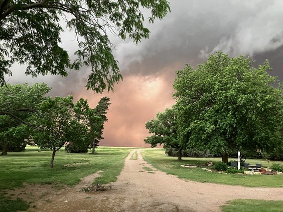
Wall of dust
Video of the dust wall provided by Kaitlyn Robl preceding the storm was aired on KAKE News as coverage of the storm’s impact commenced around 6:39 p.m. Sunday. The KAKE meteorologist referenced the phenomenon as a “haboob,” referring to the Arabic term for the event, defined as an intense wall of dust carried by a weather front. According to meteorologists, not all dust storms qualify as haboobs, which specifically reference the dust wall.
The storms frequently occur in the deserts of Arizona and New Mexico, and occasionally in Texas, due to the normally arid climate. They can also occur in areas of extreme drought, as the strong, cooler air from the storm raises dust from the ground. Haboobs are not derechos, as the derecho is defined as a line of straight line winds that create damage over a line of more than 200 miles in length with winds at least 58 mph.
Storm effects
Sunday’s high winds did prompt the City of Great Bend to shut down the new Splashpad on Monday, so that staff could clean, drain, retreat and refilter the water. A post on Explore Great Bend said they hoped to have it up and running as quickly as possible.
A barbecue with a twist
The Herb Phillips family of Heizer was enjoying a barbecue on Sunday when the wind whipped up and destroyed all the outbuildings on their farm. Their house, which wasn’t harmed, used to be the Heizer Hotel and was moved to the farm in 1924. They didn’t get any rain during the storm but they lost their granary, three-car-garage, silo, two sheds, and trees.
“The good is that all my projects are gone,” Phillips said. He was remodeling his barn and is thinking about going to metal outbuildings instead of wood.
Pawnee County weather
A National Weather Service thunderstorm warning was issued at 5:45 p.m. Sunday for Larned and neighboring communities of a storm with the potential of winds gusting up to 80 mph with rain and penny-sized hail.
The storm passed through the area considerably less than predicted; however, gusts did down tree limbs in the Larned community. Approximately .25 to a half-inch of rain was reported.
Russell County weather
The National Weather Service issued a warning for a confirmed tornado on the ground west of Russell at 3:28 p.m. Sunday.
Additional reports from law enforcement and storm spotters indicated confirmed tornadoes between Gorham and Russell and between Dorrance and Wilson.
The storm damaged homes, sheds, businesses and vehicles and resulted in a power outage in the area. City crews reported electrical service restored to most areas by midnight, with about 116 customers still without power at 9 a.m. Monday.
Kansas Highway Patrol reported a strong gust of wind pushed a Kenworth truck pulling a trailer across both lanes of westbound Interstate 70 and into the median, where it rolled onto the driver’s side. This occurred at 3:45 p.m. Sunday approximately 2.1 miles east of Exit 175. The driver, Vincent O. Weiss, 65, from St. Joseph, Mo., was taken to Russell Regional Hospital with what appeared to be a minor injury.
A large area
Meteorologist Ken Cook with the National Weather Service office in Wichita said storms developed starting around 3-4 p.m. near Hays and later Dodge City, and moved east over several hours. There was large hail in Russell but hail dropped off as the storm developed into high winds and some tornados.
NOAA’s National Weather Service Storm Prediction center logged winds of 60 mph or more in Great Bend, Ellinwood and McCracken, and portions of Rice County, and hail in Rice County.
Looking ahead
The National Weather Service on Monday said thunderstorm development was unlikely that evening in the Golden Belt. “However, if a lone storm is able to form, the environment will support severe weather.” Periodic thunderstorm chances remain in the forecast through the weekend.