
WICHITA — The National Weather Service in Wichita has issued a winter weather advisory in effect for Barton County and south central Kansas from midnight Friday to 1 a.m. Sunday.
A winter weather advisory means that periods of winter weather will cause travel difficulties. be prepared for slippery roads and limited visibilities. use caution while driving.
A strong storm system currently over the southwest United States will move east northeast into the plains late Friday into Saturday. as this system approaches precipitation will be break out across southern Kansas and eventually central Kansas.
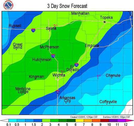
Surface temperatures near freezing across central Kansas may lead a mix of freezing rain, sleet and light snow late Friday with some glazing of ice possible. The winter precipitation will change over to all snow on Saturday with a swath of snowfall expected across south central Kansas by Saturday afternoon.
• Timing of the precipitation will gradually increase across central Kansas overnight with some freezing rain and sleet possible with surface temperatures expected to be around freezing. Colder temperatures will change the precipitation over to all snow on Saturday.
• The main impact will be freezing rain and sleet overnight. Some glazing of trees, power lines and untreated roadways will be possible. Up to a quarter of an inch of ice accumulation is possible mainly along a line from Hutchinson to Newton to Marion by Saturday morning.
• The freezing rain and sleet will transition to all snow on Saturday with two to four inches of snow possible by Saturday evening.
• Wind chills and strong and gusty north winds will increase on Saturday afternoon which may produce some blowing and drifting of the newly fallen snow. Dangerous wind chill values of minus 10 to 15 below zero will be possible late Saturday night.
A chance of snow, freezing rain and sleet is forecast from 4-5 a.m. followed by snow and sleet likely after 5 a.m. The chance of precipitation is 60 percent. Total nighttime snow and sleet accumulation of less than a half inch possible.
Saturday snow is forecast with north winds 11 to 16 mph in the afternoon with gusts as high as 24 mph. The chance of precipitation is 80 percent. New snow accumulation forecast is about two inches.
Saturday night’s forecast is a 40 percent chance of snow before midnight. Wind chill values are forecast to be as low as -13. North winds between 18 to 25 mph, and forecast with gusts as high as 34 mph.
Sunday’s high will be 16 degrees with wind chill values as low as -14. North winds are forecast between 15 to 20 mph with gusts as high as 28 mph.
Winter weather advisory posted through Sunday


