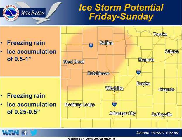

WICHITA — Multiple rounds of freezing rain will affect Central Kansas starting Friday into early Monday, according to the National Weather Service.
The freezing rain may result in hazardous travel conditions as well as tree damage and power outages. The greatest accumulations of ice are expected late Friday night into Saturday and then Saturday night into early Sunday.
For some areas roughly east of I-35 and south of Highway 54, the temperature may warm enough Saturday afternoon to cause substantial melting. This would divide the total shown between two separate events for that area. Temperatures will rise well above freezing for most of the area during the day on Sunday. Precipitation will end with sleet or snow mix across portions of Central Kansas on Monday.
DODGE CITY NWS — Significant ice accumulations possible this weekend. Freezing rain is expected to spread northwest across western Kansas Friday night. Widespread freezing precipitation will then expected over the weekend period. The potential exists for ice accumulations greater than of an inch.
TOPEKA NWS — Light freezing rain is forecast to begin across the east on Friday afternoon and continue overnight into Saturday. Heavier accumulations are expected Saturday night into Sunday morning, when damage to trees and power lines becomes more likely, with significant impacts to travel expected. There is still uncertainty to amounts with this forecast with much of the area very close to the freezing mark.
KANSAS CITY, MO. NWS — A long duration winter storm is expected this weekend as precipitation in the form of freezing rain impacts the lower Missouri Valley. The potential exists for significant icing across the area, which will make travel extremely hazardous. Additionally, ice accumulations may lead to downed tree limbs and power outages. Now is the time to prepare!

