
By JIM MISUNAS
jmisunas@gbtribune.com
A possible rain-wrapped funnel cloud convinced the National Weather Service in Wichita to issue a short-lived tornado warning for Barton County Thursday. The funnel cloud was visible from Great Bend, Cheyenne Bottoms and Ellinwood.
The warning was issued at 2:50 p.m. and was canceled at 3:02 p.m. for a storm estimated five miles north of Ellinwood moving to the northeast. Tornado sirens were sounded in Ellinwood and students were kept at Ellinwood and Claflin schools until the weather moved on.
“The storm was rain wrapped, so they called dispatch and the warning was issued,” said Amy Miller, Barton County emergency manager. “There was some updrafts going on. The schools were watching the storm closely.”
Miller said there was no reported damage and no evidence that the funnel cloud came to the ground.
The National Weather Service in Wichita issued a significant weather advisory for east central Barton County, northwestern Rice County and northwest Saline County.
Besides locally gusty winds, these storms may also produce brief funnel clouds. The funnel clouds should remain above the ground.
However a very brief touchdown is a remote possibility. If so, they could result in minor wind damage.
At 3:05 p.m. National Weather Service meteorologists were tracking strong thunderstorms along a line extending from five miles northwest of New Cambria to five miles northwest of Ellinwood moving east at 25 mph.
Hail up to the size of dimes and wind gusts up to 50 mph will be possible with these storms.
Locations impacted include Salina, Ellsworth, Claflin, Kanopolis, Holyrood, Bushton, Geneseo, Brookville, Smolan, Lorraine, Glendale, Rederick, Kanopolis State Park, Salina Airport, Kanopolis Lake and Cheyenne Bottoms.
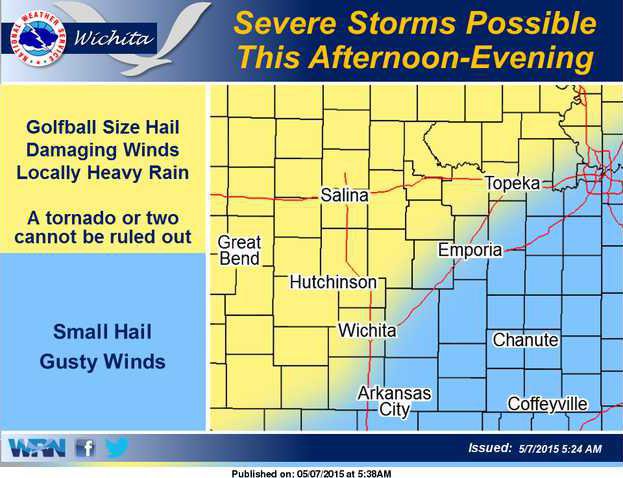
Severe thunderstorm chances continue Friday. Large hail and damaging winds are the main concerns across southern Kansas along with the potential for very heavy rainfall and flooding. A tornado is also possible especially south of U.S. 54/400 where a more significant weather threat may develop.
The severe weather threat increases significantly for Saturday. Saturday is a significant severe weather day with long-lived damaging tornadoes possible. Baseball or larger hail and winds greater than 80 mph possible.
Persons in the area should stay up-to-date on the weather this week — especially Saturday as a significant outbreak is possible.
The chance of severe storms shifts east into southeast Kansas on Sunday afternoon. Large hail and damaging are the main concerns, but a brief tornado is also possible.
Skywarn spotter activation will be needed across Kansas through most of the weekend.
No damage reported from tornado report

